- Get link
- X
- Other Apps
Introduction
A Tectonics Article By Taylor Combaluzier
General Location and Tectonic History
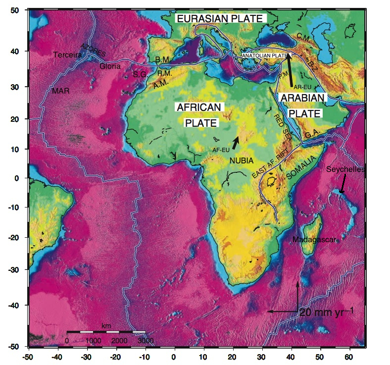
The African-Arabian region is composed of the following tectonic plates: Arabia, Madagascar, Nubia, Seychelles, and Somali (Figure 1).
The African-Arabian region is composed of the following tectonic plates: Arabia, Madagascar, Nubia, Seychelles, and Somali (Figure 1).
Figure 1: Overview of the African and Arabian tectonic plate region. Modified after McClusky et al., 2003.
|
The modern tectonic history of Africa commences with the breakup of Gondwana ~200 Ma, at which point Nubia
began to interact with Eurasia along the former’s northern margin
(Zitellini et al., 2009). Early on (~160-117 Ma), Madagascar separated
from southeastern Africa and rifted to its present location. During the
Oligocene, the Neotethys Sea (which existed between Nubia and Eurasia) closed via subduction as the two plates collided – eventually, during the Middle to Late Miocene (~10 Ma) active continental collision occurred (McClusky et al., 2003).
The Arabian plate also separated from Africa at ~25 Ma, which lead to the closure of the Neotethys sea (Johnson and Stern, 2010). Subsequent rifting between Arabia and Africa resulted in the formation of the Red Sea. |
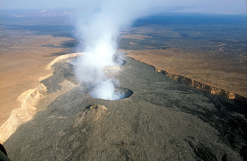
Above: East African Rift Valley, Ethiopia. (1)
|
From 10 Ma to 60 Ma the Somali plate began to separate from Africa via rifting – future modelling suggests that within 1 Ma, there will be a new sea between Somalia and Africa, and within 10 Ma it will be an entirely new continent (Logatchev et al. 1972) (Emerick and Duncan, 1982).
Finally, both the Madagascar plate and Seychelles plate are, in fact, microplates within the Somali plate, with the latter being a plateau. Approximately at 84 Ma, a spreading ridge developed that produced a new region of the Indian Ocean, from which the Mascarene Basin formed (Plummer and Belle, 2005). Hot spot magmatism resulted in subsequent rifting that separated the Seychelles from India at the Cretaceous/Tertiary boundary, and to which subsequent sedimentation created carbonate shelves on the microplate (Plummer and Belle, 2005).
|
Geological Background
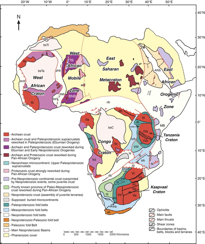
In general, both the African continent and Arabia are composed of a Precambrian basement of crystalline meta-sedimentary, meta-igneous, and igneous rocks (Figure 2) (Schlüter and Trauth, 2008). This basement is overlain by a range of cover rock – from sedimentary and volcanic sequences to unconsolidated Cenozoic sediments (Schlüter and Trauth, 2008). Africa is made up of primary units called cratons – which themselves are predominantly low-grade greenstone belts, gneisses, and granitic series (Schlüter and Trauth, 2008). Upon these foundational blocks are the aforementioned cover rocks/sediments. Figure 2: Geological map of Africa. (2) |
Current Major Motions Relative to Adjacent Plates
The Somali plate is separating from Nubia in an eastward direction at the East African Rift Valley, where rifting is occurring at approximately 6 mm/yr (McClusky et al., 2003).
The Arabian plate (Figure 4) is moving away from Nubia in a northwest direction in the Red Sea at a rate varying along the strike of the rift between 14 mm/yr and 5.6 mm/yr (McClusky et al., 2003).
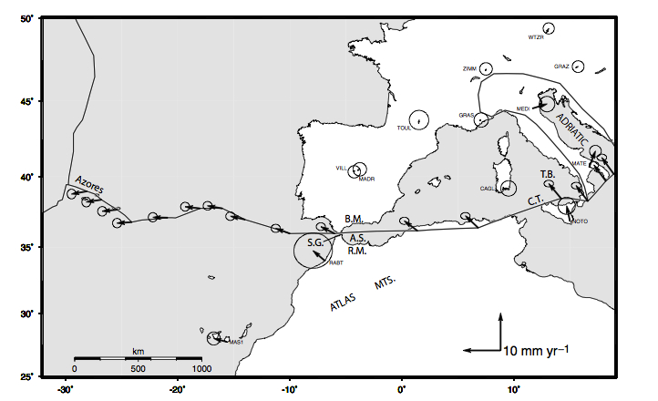
At the Mid Atlantic Ridge, spreading is occurring at an average half rate of 12-13 mm/yr (Wang et al., 2011). Whereas, collision between Nubia and the Mediterranean is in a NW-SE direction is occurring at 8 mm/yr in the eastern Mediterranean, which progressively decreases to oblique opening of 4 ± 0.6 mm/yr at the western plate margin (Figure 5) (Calais et al., 2003).
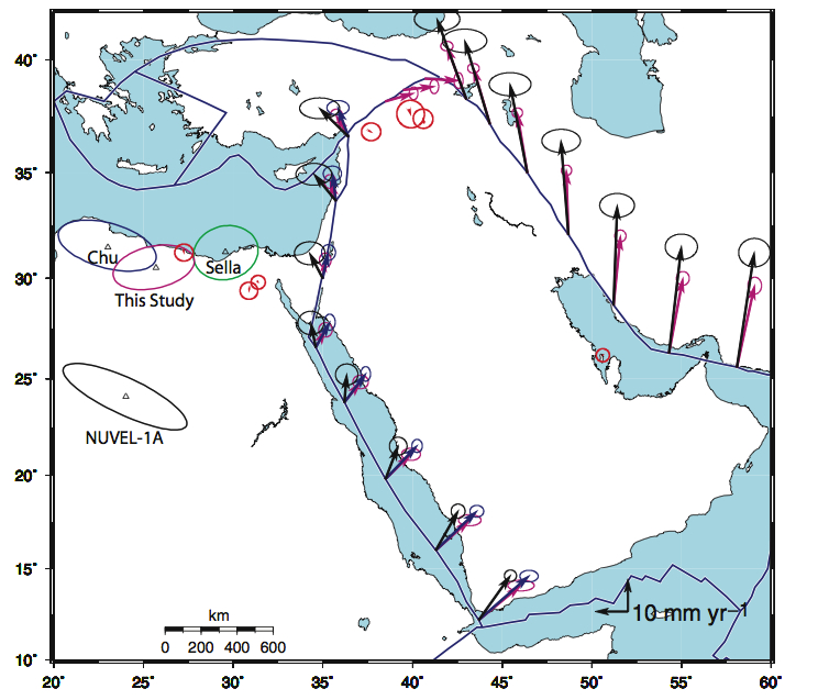
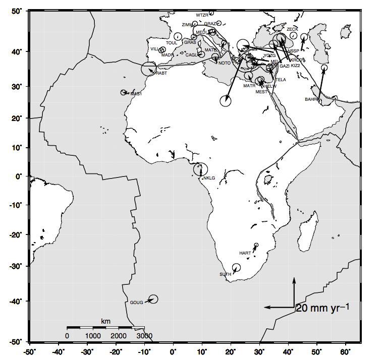
The major plate motions are illustrated below in Figure 6, wherein the Euler vectors are shown for Nubia, Eurasia, and Arabia, with respect to Eurasia.
Figure
6: Euler vectors for major plate motions in the African and Arabian
region. GPS velocities are also shown, by which the Euler vectors were
calculated. It should be noted that the ellipses represent confidence in
the GPS velocities. From McClusky et al., 2003.
|
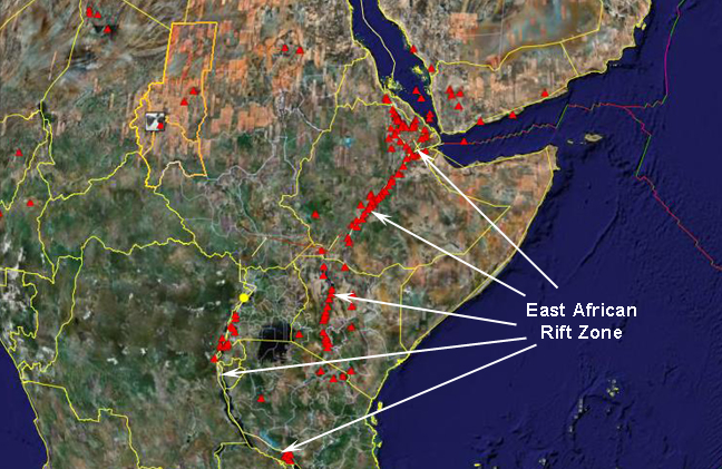
Characteristic Features Volcanism and Earthquakes This region is characterized by pronounced volcanism, which greatly influences the tectonics of the region and has vast environmental and social implications. In Arabia, volcanism is present as basalt fields and traditional shield volcanoes and cone volcanoes, with the largest volcanic field being Harrat Ash Shaam (Al Kwatli MA et al., 2012). Madagascar, an island nation, is host to five volcanoes (Kusky et al, 2007). In contrast to these traditional forms of volcanism, is the existence of mud volcanoes off the coast of Gibraltar (Gutscher et al., 2002). Most famously, however, is the presence of the East African Rift Valley between the Nubian plate and Somalian plate (Figure 7) (Baker et al., 1972). Earthquakes are also common in regions marred by extensive volcanism, as well as at transform faults - refer to the Natural Hazards page for more. |
Figure 7: The East African Rift Valley is characterized by an immense number of volcanoes and volcanic fields. (3)
|
Resources
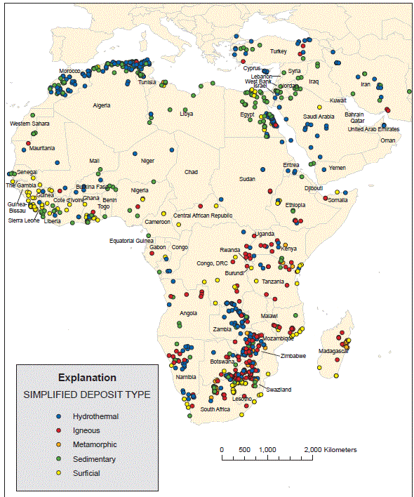
Africa is an important source of mineral resources (Figure 8), hosting approximately 30% of the worlds resources (Sharaky, 2011). The younger orogenic belts in Africa are major hosts of zinc, lead, and iron ore (Clifford, 1966). South Africa also plays host to the largest gold reserve on the planet, the Witwatersrand Basin (Taylor et al., 2009). It is also a major source of diamonds from kimberlites (Taylor et al., 2009). Finally, in today’s fossil-fuel dependent world, Arabia contains 48% of the world’s oil reserves, and therefore is a major political force across the globe (BP, 2013).
Figure
8: Classification of ore deposit types in Africa and Arabia region.
Note that hydrothermal deposits are concentrated in younger orogenic
belts; whereas, surficial deposits are located in older, cratonic
regions (i.e. the Witwatersrand). From Taylor et al., 2009.
References
Baker, B.H., Mohr, P.A., and Williams, L.A.J. 1972. Geology of the Eastern Rift System of Africa. Geological Society of America. 136: 1-68
[BP] British Petroleum. 2013. BP Statistical Review of World Energy 2013. [cited 2014 Jan 15]. Available from:http://www.bp.com/content/dam/bp/pdf/statistical-review/statistical_review_of_world_energy_2013.pdf
Clifford, T.N., 1966. Tectono-Metallogenic Units and metallogenic Provinces of Africa. Earth and Planetary Science Letters 1, 421-434.
D'Agnostino, N., Selvaggi, G., 2004. Crustal motion along the Eurasia-Nubia plate boundary in the Calabrian Arc and Sicily and active extension in the Messina Straights from GPS measurements. Journal of Geophysical Research 109, B11402.
Emerick C.M. and Duncan R.A. 1982. Age progression volcanism in the Comores Archipelago, western Indian Ocean and implications for Somali plate tectonics. Earth and Planetary Science Letters. 60: 415-428
Gutscher, M.-A., Malod, J., Rehault, J.-P., Contrucci, I., Klingelhoefer, F., Mendes-Victor, L., Spakman, W., 2002. Evidence for active subduction beneath Gibraltar. Geology 30, 1071-1074.
Kusky, T.M., Toraman, E., Raharimahefa, T., 2007. The Great Rift Valley of Madagascar: An extension of the Africa€́“Somali diffusive plate boundary? Gondwana Research 11, 577-579.
Logatchev, N.A., Beloussov, V.V., and Milanovsky, E.E. 1972. East African Rift Development. Tectonophysics, 15: 71-81
McClusky, S., Reilinger, R., Mahmoud, S., Ben Sari, D., Tealeb, A., 2003. GPS constraints on Africa (Nubia) and Arabia plate motions. Geophysics Journal International 155, 126-138.
Plummer, P.S. & Belle, E.R. 1995, "Mesozoic tectono-stratigraphic evolution of the Seychelles microcontinent", Sedimentary Geology, vol. 96, no. 1-2, pp. 73-91.
Schlüter, T., Trauth, M.H., 2008. Geological Atlas of Africa: With Notes on Stratigraphy, Tectonics, Economic Geology, Geohazards, Geosites and Geoscientific Education of Each Country. Springer.
Serpelloni, E., Vannucci, G., Pondrelli, S., Argnani, A., Casula, G., Anzidei, M., Baldi, P., Gasperini, P., 2007. Kinematics of the Western Africa-Eurasia plate boundary from focal mechanisms and GPS data. Geophysics Journal International 169, 1180-1200.
Sharaky, Abbas M. "Mineral Resources and Exploration in Africa." Egypt: Cairo University.
Taylor CD, Schulz KJ, Doebrich JL, Orris GJ, Denning PD, Kirschbaum MJ. 2009. Geology and nonfuel mineral deposits of africa and the middle east. Open-File Report - U.S.Geological Survey :246.
Wang, T., Lin, J., Tucholke, B., Chen, Y.J., 2011. Crustal thickness anomalies in the the North Atlantic Ocean basin from gravity analysis. Geochem. Geophys. Geosyst. 12, 1-25.
Zitellini, N., Gràcia, E., Matias, L., Terrinha, P., Abreu, M.A., DeAlteriis, G., Henriet, J.P., Dañobeitia, J.J., Masson, D.G., Mulder, T., Ramella, R., Somoza, L., Diez, S., 2009. The quest for the Africa-Eurasia plate boundary west of the Straight of Gibraltar. Earth and Planetary Science Letters 280, 13-50.
Generic Image References
1. http://ethiopiaembassy.eu/image/EthiopianRifValley.jpg
2. http://geosphere.gsapubs.org/content/5/1/23/F1.large.jpg
3. http://web.gccaz.edu/~lnewman/gph111/topic_units/plates/east%20africant.jpg
- Get link
- X
- Other Apps
Comments
Post a Comment